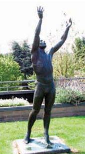
 Trestle, by John Richen, reaches for the sky near the library. Photo courtesy City website.
 One of the finest walking tours in Edmonds is the art tour. Check out the map here.
 Trestle, by John Richen, reaches for the sky near the library. Photo courtesy City website. Trestle, by John Richen, reaches for the sky near the library. Photo courtesy City website. One of the finest walking tours in Edmonds is the art tour. Check out the map here.
0 Comments
 Photo courtesy Friends of the Edmonds Marsh website. From My Edmonds News: The public is invited to a free marsh walk on Saturday at 3 p.m., led by Keeley O’Connell, senior project manager at EarthCorps.
According to O’Connell, participants will explore Edmonds’ 32-acre fresh-and-saltwater marsh that was once a 100 acre barrier estuary. This “rare habitat” on Puget Sound is home to wildlife, and there is proposed restoration to “improve the health and function of the marsh both for wildlife and the Edmonds community.” Interested walkers should meet at the Edmonds marsh boardwalk overlook at Harbor Square SW corner near Blue Collar Doghouse. The event is sponsored by My Edmonds News, TrEdmonds, and Celebrate Edmonds, as part of FeetFirst and Jane’s Walks, an international weekend celebrating walkable communities.  If you've ever wandered down the alleys of Edmonds, you know they offer a respite from the "busy" streets and avenues. And a peek into some of the sweetest gardens. Eric Brotman's article in My Edmonds News offers a tour of these backways:
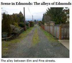
Scene in Edmonds: The alleys of Edmonds Story and photo by Eric Brotman What: The alleys of Edmonds Where: Various locations in the Edmonds bowl (the representative photo is of an alleyway running south to north from Elm Street to the Pine Street Playfield, between 6th Avenue South and ‘A’ Avenue South.) The narrow and weathered alleys of Edmonds endure as unusual urban roadways, where the traffic of neighbors and pedestrians can be greater than that of strangers and cars. Some alleys are paved, though in many spots the pavement has crumbled. Other sections have remained, or reverted to, grass-edged beds of dirt and gravel. The above photograph, taken approximately eight-tenths of a mile from the center of downtown Edmonds, could easily pass as a rural scene, and many residents with property along the quieter alleyways seem to embrace the spirit of a bygone time in their approaches to landscaping and decorative choice. No history of alleys in Edmonds has been written, so their original purpose is unclear and often in dispute. In interviews conducted in the spring of 2010, several residents of Edmonds shared their thoughts and memories of our local alleys. LeRoy Middleton, a retired civil engineer and surveyor, was 85 in March of 2010 when he unfurled a 1910 surveyor’s map of Edmonds in his living room. Between nearly every parallel set of streets an alley was indicated. When asked if the alleys might have been deliberately planned for pick-up and delivery vehicles to use, Middleton was doubtful. Such usage would have come only in later years, he explained, because “some of the oldest alleys were just grass, trees, and rocks.” He believed the first alley in Edmonds was planned by a developer who simply thought it looked good, or wanted to give people another place to walk at a time when extended walking was a common activity (Middleton noted alleys are legally considered “public ways”). He went on to say successive developers who routinely copied the design feature effectively would have made it traditional. “It’s the way they did things in those days,” Middleton said with a shrug. Mildred Kelly Engels was a few months shy of her 95th birthday in March of 2010 when she reminisced about the alleys of Edmonds. For 20 years, between 1936 and 1956, she lived along what has become perhaps the busiest alley in downtown Edmonds. It’s the one parallel to, and sandwiched between 3rd and 4th Avenues, running south to north between Dayton and Main Streets. Customers patronizing any of the three banks and several restaurants in the vicinity often drive through the alley on their way to a convenient municipal parking area. Engels remembered the alleyway mostly as “very quiet and peaceful.” As a young woman, she would see the alley narrow down to a pathway as she approached her back door. Farther along the way, the path widened into an alley again. “Everyone living along the alley kept their backyards beautiful,” Engels said. “Some of the other alleys in Edmonds were just wide and rutted grassy areas. They were very pleasant to walk through.” Jane Yost Sorensen, born in Edmonds in 1918, lived along an alley off Alder street between 6th and 7th Avenues South. As she recalled, “The alley was used for all sorts of things,” when she was 5 or 6. Coal deliveries for the home furnace were made in the alleyway, as were deliveries of milk. “Occasionally,” Sorensen said, “someone came by with a horse and trailer to pick up the garbage. It was so nice to have everything picked up in back, out of sight. The convenience was great. “Our chicken coop was out there, too. Other kids in the neighborhood would want to see the chickens if they didn’t have any of their own. “We knew everyone in every home along the alley. We were just plain neighborly.” In 2013, a number of alleys remain for walkers to enjoy while imagining what life was like when the public ways were first laid out. The City of Edmonds maintains an official street map at the City Engineer’s office. It shows all the current alleyways accessible to the public. You can almost see the course for the first TrEdmonds bike race in this map. The trails in Edmonds have been a well-kept secret until now.
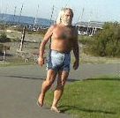
 Some folks spend a lifetime searching for Big Foot, while others prefer the elusive Temperature Taker. If you've ever seen his shirtless jorts on the Edmonds waterfront, you know why he's got oodles of Facebook fans. In fact, this photo comes from his FB fan club.
Now you don't have to bare down to your skivvies to enjoy the Edmonds waterfront, but we do recommend getting your toes nekked and into the sand. And on a summer evening, bring a fashlight to check out these moonlight walks. You can find hundreds of documented trails around the Sound, but there's little written on the back roads and walks of Edmonds.
Here's a favorite trail to get you started: Yost Park - this City of Edmonds park offers solid urban riding, and once you are done, you're three blocks from downtown cafes and bars - but this City map doesn't show you that. Just head south out of the park and follow Main Street to the watering holes. You can't get lost. |