We love the Cascade Bicycle Club's rides around Seattle! Just looked at their upcoming rides, and nothing says "Edmonds" right off, so we're checking to see if there is an Edmonds ride. Yes, we see rides through Bothell, W. Seattle, Mercer Island, etc. -- but where is Edmonds on the list? Maybe they don't know about the awesome trails in Yost, Hutt, and Pine Ridge parks.
You can tell by Matt Mikulsky's LinkedIn photo that he cares about the future. Matt recently contacted me to get TrEdmonds to the next level, past the chatter stage and into reality with trail sponsors and workout stations by artists, like iron-worker Scott Szloch. We can't do this alone, so if you're interested in taking part in this ride, please email us. And of course, get your tread on!
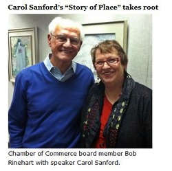
Here's an article I wrote for My Edmonds News on Carol Sanford's talk regarding finding "story of place" and using it as a foundation. I am looking forward to the discussion that she is sparking....and my hunch is everything leads to the beach. --Janette Turner
“I’ve seen worse conflicts by far than in Edmonds and I’ve seen them shift” — that was the message of Carol Sanford, speaker on “Story of Place” tonight at Edmonds City Hall Brackett’s Landing. Sanford said the root of getting factions to work together is finding the story for why folks all live in a place, and when that story is applied to every layer of business and government in the community, then the entire area is lifted. One example she gave was actor Robert Redford’s plan to build a large hotel in Sundance, Utah, but when the geological “story” of the area was unearthed, including a watershed and newly-recognized earthquake fault line, Redford realized the area needed the watershed and not a hotel. Settling conflicts by seeking out a place’s story, according to Sanford, requires interviews with legacy business leaders, keepers of the artistic spirit, regenerative governors, and citizen activators. And if we don’t seek out the “story of place” for Edmonds? Then the focus will be on what people want, which leads to conflict and a race toward the least common denominator. Clearly, that’s not a satisfying result for Sanford, a business educator, micro-economist, and new Edmonds resident. Now it’s up to the rest of the Edmonds residents and stake-holders to decide whether to seek out our town’s story of place. More information on Sanford and her expertise can be found on her website. Photo by Barry Munger. This is a long article, so you may want to skip down to the bold lines to see the value of turning rail beds into rec trails. Thanks to Jack Faris for the link.
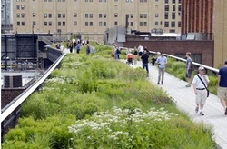
From New York Times Book Review: The Chelsea Thicket, which marks the beginning of the newly completed middle portion of the High Line, New York City, May 2011 Rarely do additions to works of architecture or engineering by the same designers who created the originals attract as much comment as the initial installments. Thus there was some question as to just how much excitement could be generated by the debut this June of the second segment of the High Line, the innovative park created atop the long-derelict New York Central Railroad freight trestle that runs along Manhattan’s far West Side between the Meatpacking District and Midtown. Upon its inauguration, in 2009, the first portion of this landscaped thirty-foot-high promenade—which extends from Gansevoort to West 20th Streets, or roughly one third of the scheme’s entire projected length, with the second part now open between West 20th and West 30th Streets—was greeted with universal praise, and rightly so. Seldom in modern city planning has a single work of urban design brought together and synthesized so many current concerns, including historic preservation, adaptive reuse of obsolete infrastructure, green urbanism, and private-sector funding and stewardship of civic amenities. Happily, the same elated reaction that greeted the first segment occurred again this summer, as the newly completed middle portion of the High Line revealed that rather than being simply more of the same, the park is evolving into a much more varied experience than many had anticipated. The second half-mile stretch feels different from the first in that its route is straighter and narrower (two tracks wide as opposed to four in the southernmost section). It makes fewer jogs and lacks the extravagantly sweeping arc of the northern end of the viaduct, which, if it is built, would bring the High Line to a dramatic culmination when the whole project is finished. Because all the park’s components are being executed by the creative team comprised of two New York–based architectural and planning firms, James Corner Field Operations and Diller Scofidio+Renfro, along with the Dutch landscape architect Piet Oudolf, the High Line feels wholly consistent and yet never repetitive throughout its mile-and-a-half length. For example, at West 26th Street, the design team has created the Viewing Spur, a bleacher-like observation perch that is a virtual cousin of Tenth Avenue Square, the much larger wooden amphitheater at the viaduct’s widest point on West 17th Street. But the Viewing Spur differs from the Tenth Avenue Square because of a huge, empty, oblong metal rectangle (the size of advertising Once again, Oudolf’s selection of botanical material is superb. This summer it featured such flowering perennials as allium, catmint, coral bells, cranebill, rosemary, salvia, and yarrow, along with trees and shrubs including chokeberry, holly, magnolia, redbud, roses, sassafras, and shadblow. His random-looking (though deliberately composed) planting beds simultaneously pay homage to the wildness of the High Line in its gone-to-seed phase and seamlessly accommodate the many functional requirements of a heavily trafficked pedestrian concourse. The new segment also remedies one of the few objections the first phase of the design raised among environmentalists: the use for the park’s benches and decking of ipê, a tropical wood whose use activists have deemed ecologically destructive and unsustainable. Since then, the designers have specified reclaimed teak, which possesses the same weather-resistant properties as the controversial earlier selection. Particular areas of the High Line have been given evocative names reminiscent of the Romantic nomenclature that Frederick Law Olmsted and Calvert Vaux bestowed on Central Park’s Belvedere Castle, Harlem Meer, Mineral Springs Pavilion, the Ramble, and Sheep Meadow. Thus in the southernmost section of the High Line we find the Gansevoort Woodland and the Washington Grasslands, while in the newly opened center portion we now have the Chelsea Thicket, the Radial Bench, the Wildflower Field, and the Falcone Flyover—the latter a raised steel walkway that refers not to raptors on the wing but its donors (a high-flying hedge fund manager and his wife). The High Line’s founders and prime movers, Joshua David and Robert Hammond, offer an absorbing account of their heroic undertaking’s genesis and implementation in High Line: The Inside Story of New York City’s Park in the Sky. The pair met in 1999 at a local community board meeting and there discovered their shared fascination with the disused elevated railway spur, which was constructed between 1929 and 1934 to bring raw materials and wholesale goods to the third-story receiving docks of warehouses, manufacturers, and food-processing plants near Manhattan’s Hudson shore. The collaborators’ decade-long evolution from amateurs—David had been a magazine writer, Hammond a consultant to start-up companies—into seasoned urban planners is an uplifting coming-of-professional-age story in which two somewhat naive and comically inexperienced enthusiasts wise up and learn what it takes to get things done in the City That Never Sleeps. Throughout, these oft-thwarted civic crusaders remained cheerily undaunted as they confronted and overcame opposition from every quarter. Not the least of the many impediments was an obstructionist neighborhood group, Chelsea Property Owners, which for a decade and a half had been trying to have the High Line torn down as a nuisance and an eyesore. With a prescience akin to those who laughed when Edison recorded sound, the Chelsea Property Owners bombarded members of the newly formed Friends of the High Line with mailings that inveighed against the trestle for, among other infractions, being too narrow to accommodate regulation jungle gym equipment. City officials proved no less hostile. As Hammond recalls, “The property owners who opposed the High Line had hired Rudy Mastro, one of [Mayor Rudolph] Giuliani’s former deputy mayors, and paid him a lot of money to lobby Giuliani, and that’s why Giuliani was opposed, in my view.” Joseph Rose, head of New York’s City Planning Commission during the Giuliani administration, called the decaying High Line “the Vietnam of old railroad structures” and declared, “It must come down.” A turning point came in 2000–2001, when the photographer Joel Sternfeld took a striking series of images of the picturesquely decrepit train bed—a veritable urban prairie lush with nodding wildflowers and shimmering grasses--that are to the High Line what the muckraking photojournalist Jacob Riis’s depictions of New York City slum dwellings in the 1890s were to the cause of housing reform: strong artistic statements but also irresistible sales tools for agents of civic betterment. In tracing the eight-decade history of the High Line, the authors resurrect a 1981 proposal by the architect Steven Holl, who would have turned the High Line into a postmodern Ponte Vecchio by stringing twee little toy-town structures down the length of the former right-of-way. This mercifully unexecuted scheme indicates how much we owe David and Hammond for insisting that new architectural interventions on the High Line agree with the bold industrial character of the existing structure. The economic benefits New York City has reaped as a direct result of the High Line are significant. The first two of the project’s three segments have cost $153 million, $133.6 million of which has come from public funds, with the balance donated by private and corporate sponsors. In addition, the Diller–von Furstenberg Family Foundation has recently announced a contribution of $20 million, the largest single donation ever made to a New York City park. In a remarkable return on investment, the High Line has spurred some $2 billion in ancillary development, primarily housing adjacent to the park, about 2,500 apartments thus far. Those units have been selling for an average of $2,000 per square foot, nearly twice the Manhattan median of $1,028. Prices in several of the new architect-designed apartment buildings near the High Line—which include designs by a roster of celebrated avant-garde figures including Neil Denari, Jean Nouvel, Lindy Roy, and Annabelle Selldorf—have lately rivaled the most expensive residential real estate transactions in any other part of the city. For example, the penthouse atop Shigeru Ban’s eleven-story Metal Shutter Houses condominium of 2008–2011 on West 19th Street sold this summer for somewhere in the range of $13 million. In addition, about a half-million square feet of new office space (the finest being Frank Gehry’s iceberg-like IAC building of 2003–2007 on West 18th Street) and a thousand hotel rooms (the best of which are in the Mexican architect Enrique Norten’s Hotel Americano of 2008–2011) have been added to the surrounding neighborhood. The High Line thus far has drawn more than five million visitors (about half from the New York metropolitan region, the rest domestic and foreign tourists), greatly benefiting local restaurants and retail businesses, and creating 12,000 jobs since 2009, an impressive figure during a period of soaring unemployment nationwide. The “park in the sky” has also had a salutary effect on the local crime rate, with not a single serious offense reported on the High Line since it opened. That is largely attributable to Parks Enforcement Patrol officers who issue one summons every other day on average, mainly for drinking, but also for bicycles and dogs, which are prohibited atop the structure. Another, less quantifiable means of crime control on the High Line is what the influential urbanologist Jane Jacobs termed “eyes-on-the-street”: day-and-night pedestrian traffic and a healthy contingent of neighborhood busybodies lead to fewer opportunistic offenses, both minor and major. Because the transformed viaduct threads its way through such a densely populated district, with many apartments and hotel rooms overlooking the walkway, Jacobs’s principle of informal but effective civilian surveillance is confirmed yet again. This phenomenon’s flip side has been experienced by nonplussed High Line visitors who have been treated to exhibitionistic displays by guests at Ennead Architects’ Standard Hotel of 2005–2008, which straddles the walkway near the park’s southern terminus. One assumes that some residents in the many new apartments that face directly onto the viaduct’s midsection will follow suit. The immense and instantaneous popularity of the High Line was instrumental in convincing the Whitney Museum of American Art’s longtime principal benefactor, the cosmetic magnate Leonard Lauder (who had vigorously opposed a move from Marcel Breuer’s Brutalist landmark of 1963–1966 on the Upper East Side), to throw his support behind Renzo Piano’s proposed scheme for a site for the Whitney near the park’s starting point in the Meatpacking District. Lauder had been so insistent that the Whitney keep the Breuer building that in 2008 he made a $131 million gift to the museum contingent on that condition. Piano’s initial design for the new site—a prow-shaped, stone-clad monolith—was among his finest in many years, a dynamic conception that showed how much more he is capable of than his flat-roofed colonnaded-pavilion formula. Initially considered a satellite of the uptown headquarters, the $680 million scheme was unveiled in 2008, a few months before the global market crash, but was set aside soon thereafter as far too expensive. Ultimately the museum decided that it could not afford both buildings and chose the downtown offshoot as its permanent home, a move propelled in large part by the High Line. (The Whitney recently agreed to lease its Breuer building to the Metropolitan Museum of Art as a branch gallery for at least eight years.) Piano’s revised design is projected to cost $720 million (a $40 million increase over the original, owed largely to inflation even with drastic reductions to the structure; the first version would now likely run over $1 billion). Regrettably, the scheme has been so watered down that it bears only the faintest resemblance to what would almost certainly have been among Piano’s masterworks. As previewed in a promotional video screened at the groundbreaking ceremony in June, the future Whitney—a collision of ungainly horizontal and vertical forms sheathed in white metal paneling, with a corporate-looking interior sadly reminiscent of Yoshio Taniguchi’s soul-killing Museum of Modern Art expansion of 1997–2003—seems destined to be a huge architectural letdown when it opens in 2015. Understandably, several American cities are attempting to replicate the High Line’s enormous success, an analogue to the so-called Bilbao Effect after the sensation caused by Frank Gehry’s Guggenheim Museum Bilbao of 1991–1997. In Seattle, James Corner Field Operations has been asked to replace a tumbledown elevated highway on the city’s waterfront with a sequence of parks and recreation facilities, while in Atlanta the firm is undertaking a $2.8 billion conversion of the twenty-two-mile-long railway loop that surrounds the city. But as James Corner himself has cautioned, “The High Line is not easily replicable in other cities. It’s not just, ‘Build a cool park and they will come.’ It’s, ‘Build a cool park and connect it to a framework.’” Other communities have realized that it can cost less to recycle defunct infrastructure than to rip it out. A Philadelphia business improvement coalition has estimated that the city’s old Reading Viaduct could be rehabilitated for $14 million less than the $50 million it would take to knock it down. Those plans are tied to the recycling of an adjacent office tower into apartments, anticipating a real estate ripple effect of the sort experienced not only in the environs of the High Line, but also along New York’s Fifth Avenue a century and a half ago after the creation of Central Park. David and Hammond’s High Line is above all an inspiring case study of how major city-planning initiatives can be realized without either the authoritarian methods of Robert Moses—New York’s mid-twentieth-century public works czar, whose pursuit of vast infrastructure and urban clearance projects often ran roughshod over democratic procedures and working-class neighborhoods—or today’s characteristic commercially driven redevelopment schemes. The new book’s pictorial second half includes frightening images of the Metropolitan Transit Authority’s abortive 2007 attempt to redevelop the old Hudson Rail Yards—the largest remaining open parcel on the island—directly north of the High Line’s upper terminus. The byzantine Hudson Yards boondoggle, which would have resulted in yet another unneeded enclave of high-end office space and luxury housing, was everything that the High Line is not: inhuman in its colossal scale, undemocratic in its exclusivity, and geared to private profit rather than public benefit. The sports stadium component of that controversial scheme was halted by an unlikely coalition of entrenched real estate interests—for whom this speculation by a group of insiders went beyond even their compromised notions of transparency—and community activists who see this project as a corporate land grab, but the scheme is far from dead. Without any unnecessary editorializing, Joshua David and Robert Hammond offer the image of that postmillennial Alphaville as a clear choice between two very different visions of their city, whose strength resides in its constant self-reinvention as an Isle of Joy for all. Article by Martin Filler; review of "High Line: The Inside Story of New York City's Park in the Sky," by Joshua David and Robert Hammond. Daily Journal of Commerce posted this story by Lynn Porter:
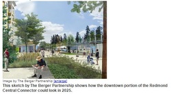
The city of Redmond has started building what will be a four-mile recreational trail on a former railroad corridor called the Redmond Spur, from the state Route 520 interchange to the northern city limits. By September it expects to complete the first mile — through downtown — of what will be called the Redmond Central Connector. Since acquiring the spur from the Port of Seattle for $10 million in 2010, Redmond has revamped its street grid to connect downtown with Redmond Town Center, said Parks and Recreation Director Craig Larsen. “Up until about a year ago, this corridor split our town in half,” he said. With a more functional street grid, the city now plans in the next two years to convert the one-way Cleveland Street and Redmond Way through downtown into two-way streets. This mean better access to businesses and shops, and should make new development easier, Larsen said. “There are a lot of properties that I think have languished because the traffic pattern is so difficult,” he said. Larsen said the trail is already increasing property values along Cleveland Street, downtown's main pedestrian and shopping thoroughfare. “Cleveland backed up to railroad corridor and you couldn't get any value out of that side,” he said. “Now we're improving that rail corridor, so you have basically two great fronts on your building.” Mixed-use apartment and condo buildings along Cleveland are also being built to overlook the trail. “We're actually seeing people modify their plans to take advantage of this corridor,” Larsen said. The Redmond Central Connector is expected to cost $9.25 million. It will be made of asphalt, concrete and pavers, and mostly will be 12 feet wide, though intersections will be up to 30 feet wide. Along the trail will be small parks and art. A light rail station is planned adjacent to the trail west of Leary Way and south of Cleveland Street. The Berger Partnership did the master plan and design, and Road Construction Northwest is building the Connector. The city intends to start construction on the last two phases this year and complete them in 2014. Phase two extends 1.3 miles to Willows Road and DigiPen Institute of Technology in the Willows business district. Phase three runs from there 1.6 miles to the Redmond border at Northeast 124th Street. “We expect that this trail will deliver thousands of people into the Redmond downtown,” Larsen said. Redmond wants to connect its trail to the one being planned by the city of Kirkland. In the short run, Redmond hopes to build 3/4th of a mile of shoulder and other improvements through a short section of rail corridor in King County to connect to Kirkland's trail. In the longer run, Redmond hopes to use more of the county's corridor to connect to the Kirkland trail. Larsen said both cities have “very attractive downtowns” and there's interest from people in being able to live in Redmond and work in Kirkland or vice versa, using the trail to commute. Pam Bissonnette, Kirkland's interim public works director, said her city is working with Redmond to connect the trails and foster the live-work scenario between the cities. “We're very interested in that and seeing that synergy — definitely,” she said. |